The Impact of Flooding on Agricultural Communities in Yemen

Executive Summary
Yemen’s agricultural communities face a perfect storm of growing ecological threats amid protracted conflict. Flash floods destroy farms, crops, and irrigation systems. Late rains risk drowning mature harvests, and waterlogged fields hinder root growth. Coastal areas battle salinization, and collapsed roads and buried wells hamper recovery. As flooding and changing rainfall patterns undermine yields, farmers struggle to sustain their livelihoods. Over half of Yemen’s population is dependent on farming and agricultural work for income. Terrain altered by flooding has stirred tensions as property lines and irrigation channels shift, displacing communities already uprooted by the war. Traditional flood management faces pressure from uncoordinated development and fading communal cooperation, and information gaps persist due to outdated estimates and limited monitoring capacity.
Stakeholders are employing various strategies in order to adapt. Some communities are able to divert excess water flows and rebuild cooperatively. NGOs are rehabilitating degraded lands and establishing early warning systems. Private sector actors have improved monitoring to fill gaps in government data. But disjointed and inconsistent policies, a lack of coordination among stakeholders, limits on women’s participation, and widespread financial hardship all weaken comprehensive risk management.
This paper examines the impact of floods on agricultural communities, based on the discussions and outcomes of a workshop implemented by the Rethinking Yemen’s Economy initiative with representatives from different governorates. It presents an analysis of the impacts of flooding and explores local prevention, mitigation, and adaptation measures. It concludes with policy recommendations to mitigate flooding and its impact on agricultural communities, enhance food and water security, and build resilience against future extreme weather events.
Selected policy recommendations:
- Mainstream climate change considerations into national policies and strategies across sectors, while taking into account the indigenous experiences of communities in forging climate resilience.
- Develop and implement a national strategic plan for a unified early warning system that integrates local capacities and coordinates across regions.
- Establish a disaster risk reduction strategy, and fund and support the implementation of flood management plans, agricultural resilience projects, and climate adaptation at national and local levels.
- Prohibit agricultural, residential, and commercial development in flood-prone areas and protect existing agricultural lands from urban encroachment through legislation.
- Decentralize flood management and agricultural protection planning by promoting collaboration between local authorities, farmers’ cooperatives and communities, and research organizations with technical and financial support from national ministries and international organizations.
Introduction
Though there is limited data, extreme weather events in Yemen, such as storms, droughts, and flash floods, appear to be becoming more severe and more frequent, with devastating effects. Houses and farmland are lost, livelihoods upended, families displaced, and people killed by extreme weather events and the damage they cause. Projections suggest there will be further changes to rainfall patterns and rising temperatures, bringing increased drought and desertification, exacerbated by the over-extraction of groundwater for irrigation.[1]
With more severe storms expected to hit Yemen’s coast, flooding threatens to destroy dams and other infrastructure.[2] Flash floods are already a major problem. During periods of heavy rainfall, there is no time for water to seep into the earth and recharge depleted underground aquifers, and floodwater can wreak havoc before it runs off into the desert to evaporate. Floodwaters sometimes flow right through neighborhoods, as poor land use practices, such as deforestation and unplanned urban development, compound the problem. Extreme weather events contribute to soil degradation, crop failure, damage to infrastructure, and increasing competition over scarce resources.
Of all the natural disasters in Yemen, floods pose the greatest threat to communities and agriculture.[3] As one of the countries most vulnerable to climate change,[4] “renewed interest in early action against floods at all levels should be considered as a matter of urgency.”[5] Addressing the impact of flooding is an essential part of any strategy to restore the agricultural sector.[6]
Yemen’s agricultural production is vulnerable, and food insecurity and the threat of famine make protecting and improving existing crops crucial. Given the country’s rapidly depleting water resources, there is an urgent need to reform agricultural policy towards sustainable, locally-grown foods that do not strain the water supply in order to bolster food security. Yemen is highly dependent on imported foodstuffs: a 2023 report estimated that imported food made up 83 percent of Yemenis’ daily sustenance;[7] in 2022, traders imported nearly 3,700,000 metric tons of basic food commodities.[8] This high import dependence leaves Yemen acutely vulnerable to external food supply shocks and global price fluctuations. The UN’s Food and Agriculture Organization (FAO) estimated that domestic agricultural production must increase by 60 percent to provide food security.[9] It is imperative that Yemen investigate the impact of extreme weather events on agricultural activities so that it may develop appropriate solutions and policies to respond.
The Rethinking Yemen’s Economy initiative, implemented by the Sana’a Center for Strategic Studies, DeepRoot Consulting, and CARPO – the Center for Applied Research in Partnership with the Orient, organized a three-day local engagement workshop in Seyoun, Hadramawt, aimed at addressing flash floods and mitigating their negative effects on agricultural communities. Participants, totaling 22 individuals (16 men and six women) from seven governorates (Sana’a, Marib, Taiz, Lahj, Aden, Hadramawt, and Al-Mahra), included members of local non-governmental organizations (NGOs) and women’s organizations, farmers, private sector actors, representatives of agriculture cooperatives, youth activists, civil defense personnel, Ministry of Agriculture officials, and individuals involved in dam projects. The workshop emphasized the need for collaboration between the government, international community, private sector, and local authorities to support affected communities amid the armed conflict and continuing instability. Drawing from the workshop, this paper provides an analysis of the impact of flooding, and discusses local prevention, mitigation, and adaptation measures which could preserve agriculture. It concludes with recommendations to enhance the resilience of agricultural communities.
Background
Food and economic security
Heavy storms and severe flooding have affected agriculture production and contributed to the destabilization of the fractured Yemeni state, considered the second most fragile of 179 surveyed worldwide.[10] During the current conflict there have been seven major flooding events and five cyclones that also resulted in severe flooding.[11] These have a direct impact on food security. In 2022, 63 percent of the total population (19 million) were unable to meet their daily food needs, compared to 53 percent (16.2 million) in 2021.[12] The crops most affected by extreme weather events in Yemen are cereals such as sorghum, wheat, and barley. These are also the main crops grown for subsistence agriculture. Cereals are particularly vulnerable to flooding – if the topsoil is washed away, valuable nutrients, shallow root systems, and seedlings are also lost. Any rise in the severity and frequency of storms would seriously impact agricultural productivity and thus food insecurity throughout Yemen.[13]
With over half of Yemenis dependent on agriculture and livestock for their livelihoods,[14] severe weather also imperils the economic security of many local communities.[15] Flooding has led to the destruction of crops throughout Yemen, making it difficult for many farmers to make ends meet.[16] Rainfall in July 2022 was nearly 300 percent above average;[17] the typically dry governorates of Hadramawt and Al-Mahra had extremely wet weather, and highland governorates such as Sana’a, Dhamar, and Amran saw heavy downpours. Thousands of acres of agricultural land were flooded and equipment and infrastructure, such as roads and dams, were destroyed, and many farmers remain unable to use their land as they cannot afford the high cost of repairs.[18] The result has been crop losses, reduced yields, and disruptions to the agricultural supply chain.[19]
Yemen is both among one of the countries most vulnerable to climate change and among the least prepared to mitigate its impact.[20] But initiatives to adapt to its potential effects, including effective management of flash floods, are largely absent, and the government is not well-positioned to respond.[21] Changes in rainfall patterns and increased flooding could further threaten agricultural production, which in turn would exacerbate the country’s food insecurity and economic crises.
Agricultural yields
From 2017 to 2021, Yemen has maintained agricultural production across a range of key crops including cereals, fodder for livestock, fruits, vegetables, legumes, and qat — despite political and economic instability.[22] The area of land under cultivation has increased gradually, from 1,084,001 hectares in 2017, to a total of 1,195,457 hectares in 2021 (Figure 1). While production levels varied depending on the commodity, growth was generally positive.[23]
The area under cultivation for cereals increased from 512,659 hectares in 2017, to 576,708 hectares in 2021.[24] Production fluctuated significantly over this period, ranging from a low of 358,355 metric tons in 2017, to a high of 879,342 metric tons in 2021, suggesting variable conditions greatly affect yields. Cash crop production was even more volatile, ranging from 73,590 metric tons in 2018, to a peak of 108,354 metric tons in 2021, despite a slight decline in the area under cultivation. Vegetable and legume production rose from 890,477 metric tons in 2017 to 1,269,305 metric tons in 2021, and fodder production increased over 30 percent, from 1,587,944 metric tons in 2017, to 2,210,500 metric tons in 2021. Similarly, fruit production grew over 20 percent, from 903,472 metric tons in 2017 to 1,087,105 metric tons in 2021.[25]
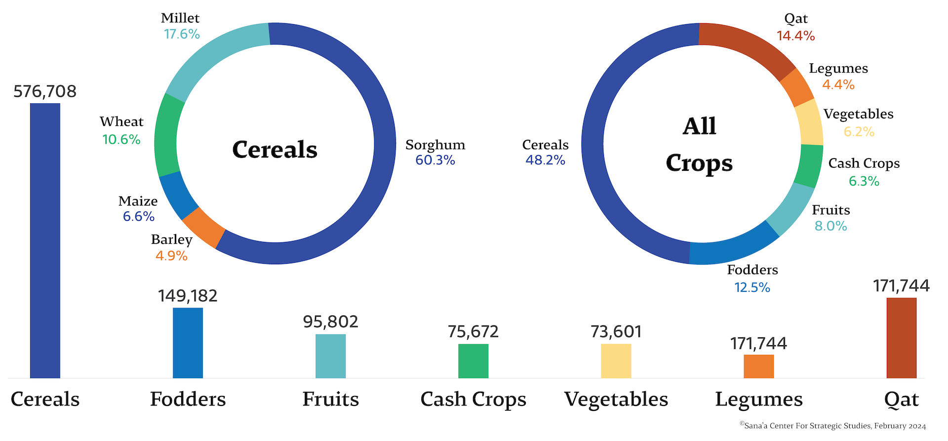
Figure 1. Agricultural area (hectare) by type.[26]
Cultivation varies substantially by region according to local conditions and market demand. Workshop participants from Sana’a reported cultivation of corn, wheat, barley, sorghum, and millet. In Hadramawt, the dominant crop is wheat, followed by sweet corn, which is primarily used as fodder. Tobacco, barley, and wheat feature prominently in Lahj, while sorghum is predominant in Al-Gharb. Wheat cultivation is especially dominant in the Al-Maseela region of Al-Mahra governorate. In recent years, farmers have planted crops that provide rapid and lucrative periodic returns. For example, in Hadramawt, farmers have increasingly turned to onion cultivation owing to strong demand from Saudi markets.
Impacts of Flooding on Agriculture
Direct impact on crops
Flooding has different impacts depending on the region and which crops are planted in flood-zones. Floods enhance siltation and increase fertility in low-lying valleys and plains by depositing nutrient-rich sediments from the hills. However, flooding also contributes to soil erosion, destruction of farmland, and harms soil composition. Coastal areas face additional risks from cyclone-driven seawater intrusion.[27] Floods of saline water in Al-Mahra and Hadramawt have increased soil and groundwater salinity, rendering some land unfit for irrigation.[28] Cyclones also change the composition of agricultural land by depositing heavy sediments and rocks on top of tilled soil. Overall, the increased frequency of flooding has had significant negative effects on agricultural production in Yemen. In Sana’a, cereal crops such as barley, wheat, corn, sorghum, and millet have been damaged as floods sweep away fertile soil. Dry fertile plains with fine soil, such as the sandy coastal plains in Tehama, are particularly vulnerable to the loss of soil nutrients during floods.[29]
Late-season flooding poses a further risk by potentially submerging mature crops, destroying the harvest. In other cases, excessively waterlogged fields facilitate root-rot and decrease productivity if not properly drained. Extreme weather can delay cultivation, disrupt agricultural timing and planning, and cause lost revenue for farmers. Collectively, these impacts undermine livelihoods and food security in already vulnerable regions.[30]
Cereal crops such as wheat and barley remain important sources of food and income in Yemen. They play a crucial role in supporting farming communities. Even light flooding can cause excessive waterlogging, soil erosion, or contamination, leading to crops that are unsuitable for consumption or sale. This has a snowball effect, as farmers who experience a decrease in income face further difficulty covering the expense of future farming activities.
Damage to infrastructure
Torrential floods irreparably damage essential infrastructure, agricultural equipment, and roads,[31] halting transportation of produce and machinery and making recovery difficult or impossible for farmers. Groundwater wells are buried under sediment left by floods, rendering them unusable. The loss of valuable water resources further compounds the challenges farmers and local communities face. Approximately 80 percent of the roads in Hadramawt are repeatedly damaged by floods. In 1993, floods in Aden destroyed traditional water-catchment systems known as saharij and submerged wells and agricultural land. In 2023, heavy rains west of Sana’a ripped open the Al Mahwit dam.[32] The resultant flood washed away a mosque, damaged roads and houses, and filled farmland with detritus as water ran through the valley below. Four people were killed.
Landmines
Due to the ongoing conflict, the landscape of Yemen is contaminated by explosive remnants of war. Many farmers have lost access to their agricultural and pastoral lands due to military action and the continued presence of landmines and unexploded ordnance.[33] Intense rainfall and flash floods have served to scatter these further, redistributing explosives deeper into agricultural areas. In March 2023, heavy rainfall in Bayhan district swept a number of landmines into private agricultural lands.[34] Similar incidents have led to numerous injuries and fatalities among civilians and put additional pressure on the already fragile agricultural sector.[35]
Social conflict
The impact of floods on neighborhoods and housing is a significant concern. Tensions rise as people blame one another for disrupting natural or extant drainage systems. Floods can alter land features and destroy fences or structural boundaries around private property, leading to disputes. The war has also driven up land prices, and new construction for internally displaced persons (IDPs) has altered the flow of drainage channels.
In Al-Ma’afir, in Taiz governorate, conflict was triggered by redrafted land borders after floods washed away boundary markers. Poor documentation in Hadramawt likewise resulted in legal and social disputes after flooding in 2008. As one farmer noted, “We return to the main landmarks in the valley and redraw borders with the same areas — but perhaps in different shapes.”[36] This common practice is not a formal solution, and may lead to further disputes. Landowners may claim certain tracts are rightfully theirs, and demand the current holders repurchase the plots. Redrawing land boundaries and resolving disputes requires clear laws, due process, and effective conflict resolution mechanisms, none of which are currently in place.
When Aden flooded in 1993, government-owned farms were completely destroyed. These farms were the legacy of the former South Yemen’s nationalization of farmland, where state-run agricultural collectives were managed by the socialist government.[37] The devastation resulted in neglected farmland and disputes over control, ultimately leading to migration, social instability, and a decline in farmers’ incomes.
When established patterns of water flow are altered, farmers experience difficulties managing irrigation and drainage on their lands, leading to bitter disputes over water access and rights, and untold damage to crops. In Wadi Ideed, near Tarim in Hadramawt governorate, conflicts arose due to modifications made to rain sluices, which redirect and manage quantities of flood discharge. Changes in flood management infrastructure sparked clashes, resulting in multiple kidnappings and serious injuries. Floods in neighboring Tarim resulted in conflicts between farmers that required legal intervention.[38]
The walled city of Shibam, an archaeological outpost and UNESCO World Heritage Site,[39] was also damaged by the Tarim floods, representative of the wide-ranging impact water management can have on cultural sites.[40] The war, flooding, and poor maintenance led to the city being placed on a list of endangered UNESCO sites in 2015.[41]
Displacement
Floods have severe impacts on communities, including through the destruction of crops and erosion of agricultural land that many families rely on for their livelihoods. These catastrophic events displace thousands of people, who must seek safer areas or alternative employment.[42] But the process of relocation brings new challenges, including disputes over land. In Hadramawt, Wadi Ada, and Marib, flooding in 2020 and 2021 caused extensive damage to IDP camps and prompted residents to migrate to towns far from their original lands. In Al-Mahra, flooding also forced people to seek temporary residence in other areas. Displacement requires affected individuals to adapt their occupations and activities to new economic circumstances, decreasing the number of farmers in the workforce and the number of farms in operation. Related financial burdens further exacerbate the hardships faced by those affected. Some farmers ultimately abandon their land entirely. In addition to physical damage, floods have significant psychological effects on families and communities, with long-lasting impacts on well-being and resilience.
Health concerns
Floods act as vectors for diseases and pathogens, and spread solid waste, chemical waste, and effluents from cities to waterways and agricultural land, impacting crops, soil quality, and productivity. Plastics and other pollutants accumulate in fields and damage yields over time. Contaminated water and waterborne diseases pose serious threats to human health. This is a critical wartime issue, as public services such as waste collection and sewage treatment are disrupted. In many cases, wastewater is discharged into storm drains without treatment. Flooding contaminates wells that are vital sources of drinking water and irrigation. The loss of access to clean water poses significant health risks and further hampers agricultural production, amplifying food security concerns.
Management and Mismanagement: Stakeholders, Initiatives, and Roles
Mismanagement of natural disasters
Various factors exacerbate the impact of floods and increase damage to cereal crops. Mismanagement of flood prevention measures, such as failing to clear flood canals and removing flood-control trees in barrier zones, leave areas more vulnerable to flash floods. The traditional local practice of diverting rainwater runoff for irrigation can become problematic as rainfall intensifies – the collapse of diversion and storage structures can drive floodwaters into residential neighborhoods and destroy infrastructure, as seen in Bur, a village in Hadramawt.[43] Altering natural drainage patterns, combined with construction in flood zones, compounds such issues. Problems often stem from inappropriate construction or unregulated changes to drainage.
Urbanization also contributes to flooding in agricultural regions. In areas such as Ibb and Taiz, rapid increases in population, urban expansion on the outskirts of cities, fragmentation of agricultural holdings through inheritance, and the manipulation of water channels by property owners and influential individuals have exacerbated the impact of floods. Urban enclosures, which often use steel, iron, concrete, and other impermeable materials, disrupt the flow and quantities of floodwater, damaging both urban neighborhoods and outlying agricultural zones. Urban development policies have diverted floodwaters into the sea in Wadi Hadramawt, wasting fresh water in a region heavily reliant on groundwater for irrigation.[44]
Some international interventions have proceeded without a requisite understanding of the local social context and environmental conditions, unintentionally altering traditional dynamics. A development project in Wadi Hadramawt disrupted natural drainage systems and rain-fed agriculture by transforming the valley into an elaborate irrigated system. As a result, floods are no longer used for irrigation nor do they enrich the land with nutrients, and runoff does not recharge local water resources. While intended to develop the region, the project has inadvertently exacerbated the negative impacts of flooding and wastes precious water resources.[45]
Government measures
Despite the ongoing conflict, the local authorities have implemented measures for flood management and agricultural protection. These include the construction of channels in Marib known as bahi to redirect floodwaters for irrigation. Marib authorities have also created barriers known as al-senah to prevent erosion during hurricanes. These embankments span a distance of 40 kilometers, safeguarding valleys below from flood-related damage. Gabions have been established along the banks of valleys to protect agricultural lands from soil erosion during flooding.
The Social Fund for Development has addressed sediment accumulation in diversion channels and irrigation canals in Marib by hiring public servants to maintain and clean the channels.[46] Organic sediment removed along the sides of valleys is composted and is used for cultivation. As a part of the World Bank’s Groundwater and Soil Conservation Project, water societies have been established to collect and distribute rainwater, which in turn play a significant role in reducing runoff and consequently the impact of floods.[47] The Environmental Protection Authorityin Hadramawt has even developed an emergency response plan for environmental disasters,[48] though its effectiveness has not yet been evaluated. The Civil Defense authorities in Mukalla have set up a system with water measurement stations and cameras to monitor natural disasters and climate conditions.[49]
But official interventions have mostly been reactive instead of proactive, and comprehensive measures are needed. Local customs governing irrigation and water harvesting practices play a role in flood management, and associations of water users have been formed under civil society projects such as the Conservation Project.[50] However, as relatively new groups, questions remain regarding these associations’ long-term effectiveness and sustainability once currently funded projects are completed.
Coordination issues and overlapping roles among government agencies represent another challenge. During the clearing of flood channels, the Real Estate Authority distributed property rights to individuals who had built on, farmed, or owned lands in flood zones. The distribution of land ownership in wadi beds and along wadi banks is likely to disrupt the course of the wadi, causing it to deviate from its natural path and negatively impact nearby properties. The practice also creates problems between new owners, especially when renewed floods erase visible boundaries between them. Funding for flood management has been inadequate, as international financial support has decreased. In the absence of state management and oversight, citizens who personally benefit from improper water management have taken it upon themselves to prevent contractors from completing canal projects.[51] The absence of regulation has led to a lack of coordination and poor governance of flood-related infrastructure projects, highlighting the importance of local engagement and locally-led initiatives.
Local initiatives
Communities in Yemen have demonstrated resilience and cooperation in flood management. In Sana’a, farmers in many areas assist one another by diverting excess water from their lands during floods, aiming to minimize collective damage. After floods, they work together to rebuild damaged terraces and canals. In Abyan, water is guided from higher to lower elevations by a traditional form of irrigation channel.[52]
Farmers supplement traditional diversion and draining systems by using water catchment containers to manage excess floodwaters and safeguard their farms. To protect lives and housing during floods, locals open water gate valves or irrigation canals to redirect water away from residential areas. In valleys, barriers are quickly constructed from local materials like palm trunks and stones, and materials like norah, a type of traditional cement, are utilized to reduce the force and velocity of floodwaters, minimizing downstream harm.[53] Planting bamboo also helps prevent erosion and stabilize valleys.
Role of women in managing floods
Women have taken on a greater role in the management of agricultural land and flood response as the war continues to draw men away from their homes. In Lahj, a woman was elected by farmers to regulate disputes resulting from flash floods. Women traditionally have a strong role in the mediation of conflict, and lead local efforts to resolve flash flood disputes in Abyan. In Maqbanah in Taiz, women have taken on the management of lands and have led flood responses, as few men remain in the village. In Khanfer and Zanjbar in Abyan, women have assumed prominent leadership over community issues, including flood management and crop cultivation.[54] But overall, the role of women in decision-making processes, dispute resolution, and resource management in relation to flooding remains weak.
Women’s limited participation in flood management can be attributed to various factors, including restrictive cultural norms, societal expectations, bias, and gender disparities prevalent in the region. Disputes over lands, flood damage, and water rights among intermarried families highlight the complex interplay of social relationships and gender. Promoting gender equality and including women can improve community expertise and mitigate floods’ adverse impacts on crops and communities.
Role of agricultural cooperatives
Agricultural cooperatives historically played a significant role in irrigation and farm management, especially in the former South Yemen. They managed canals, supplied tools, seeds, and funds, and received half of the harvest in return. The state supported agricultural cooperatives by providing funding for their operations.[55] However, after unification, their influence declined significantly, and the organizations became more symbolic. Cooperative markets are now rented out as event spaces, reflecting their diminished importance. Involvement in agricultural cooperatives is now limited in many farming communities, and many have transformed from providing services to operating purely as trade platforms.
Despite their limited reach, agricultural cooperatives have proven effective in managing flood risks. In Sana’a, they modernize irrigation and rainwater harvesting systems.[56] In Sharjan in Abyan, they maintain surface canals.[57] Some societies play an advisory role in the construction of gabions and groundwater canals. In Shibam in Hadramawt, the Rabah Society focuses on cleaning and restoring the valley watercourse and flood barriers before seasonal rains.[58] Involving agricultural cooperatives in flood prevention initiatives could contribute to more comprehensive flash flood management strategies.
Role of the private sector
The private sector works to mitigate flooding to protect its investment in Yemen’s agriculture sector. In Hadramawt, government authorities have compiled 20-30 years of data from flood monitoring stations. However, stations’ limited staff and limited distribution prevents comprehensive monitoring, analysis, and prediction. To address this gap, the private sector has provided additional stations, collecting and disseminating extreme weather bulletins. Private companies also partner with the Ministry of Agriculture to provide services, such as providing suitable climate monitoring equipment. These companies are already working in agriculture, and some produce honey or cultivate high-value plant oils extracted from jojoba, moringa, or frankincense trees.
One such company, Organic Yemen, has established climate monitoring stations and collects hydrological monitoring data. They work to develop partnerships with government agricultural institutions, such as the Agricultural Research Corporation and Meteorological Authority, which own monitoring stations that have collected historical data for 20-30 years. However, the number and coverage of these stations remains limited. By bridging data gaps and connecting farmers to vital information, such private initiatives can complement government efforts to manage the risks from flooding.
Role of non-governmental organizations
Local and international organizations play an important scientific and technical role in mitigating the impact of floods. They have also been involved in establishing early warning systems to enable timely responses to flooding. NGO initiatives include gabion installation to control erosion and manage water flow, canal maintenance, and flood impact reduction. Local NGOs produce reports on flood management and conduct outreach to educate communities on flood risks and possible solutions. International groups like the World Food Programme (WFP) and the Food and Agriculture Organization (FAO) rehabilitate flood-affected lands using their considerable resources, expertise, and financial support. The FAO supports the establishment of water user associations, but the effectiveness and continuity of these associations after funded projects end is unclear — they may serve only to resolve disputes. The German development bank KFW, through the Social Fund for Development, engages in cash-for-work programs, which provide temporary employment to help flood-stricken communities to recover and restart their agricultural activities. ACTED responds to emergencies and supports flood-affected communities.
Organizations also contribute to the establishment of irrigation works, rainwater harvesting tanks, and diversion canals, which enhance flood management. Relief efforts following floods help alleviate their immediate impact on agriculture and support affected people.
Challenges and Opportunities
Data and infrastructure
During the workshop, several participants stressed the importance of accurate data to inform sustainable agricultural practices. However, it was noted that the data provided by many official authorities has gaps, and relies on outdated census estimates rather than updated field data. Accurate measurements of fields and their output are needed to account for evolving climatic, economic, and development factors not captured in past assumptions.
While local agriculture offices still exist – Hadramawt’s directorates each have an office – the lack of systematic operational programs and long-term funding has hindered comprehensive, sustainable data gathering. Developing agricultural databases and strengthening local capacities through education and dedicated agricultural monitoring would help address information deficiencies, assess vulnerability and food security, and facilitate applications for climate-responsive funding.
Early warning systems
The devastating effects of floods demonstrate the need for reliable early warning systems (EWS) to enhance disaster preparedness and response. In any emergency, having access to accurate and timely information is crucial. An effective EWS ensures that relevant data on weather patterns, flood levels, and potential risks are quickly shared to enable proactive decision-making. An EWS allows farmers to take necessary precautions, such as adjusting planting schedules, implementing protective measures for crops, initiating evacuation plans, or harvesting early. Additionally, an EWS provides vital information to potentially flood-affected areas, enabling farmers to prioritize efforts and efficiently direct emergency assistance.
Policy constraints
Flood amelioration faces a number of policy constraints. Laws are poorly codified, which leads to uncertainty and overlapping roles among agencies, fragmenting flood risk management approaches. A unified framework integrating EWS and flood response strategies across sectors would make prevention and response more efficient. Government-led reconstruction, which is limited, often prioritizes compensation for lost housing over support for affected farmers. Reconstruction policies would better assist farmers if they comprehensively assessed crop value, damages, lost income, and displacement. Development of a more thorough reimbursement system would require transparent assessments. Addressing such constraints could complement technical adaptation efforts.
Impact of prosopis juliflora
Prosopis juliflora (known locally as saysaban) is an invasive plant species that has proliferated widely in Yemen, obstructing waterways and slowing agricultural production in governorates such as Hadramawt, Abyan, and Lahj. One reason for this poorly planned agroforestry is a policy that grants land rights to whoever cultivates a plot, not whoever owns it, which leads to lands being planted with low-maintenance trees to maintain ownership rights. The presence of prosopis juliflora trees is a significant obstacle to effective flood management, as they obstruct wadis and have replaced cultivated crops in fertile and arable lands. Prosopis juliflora trees have also come to dominate fertile valleys where palm tree cultivation used to thrive.
Traditional practices
Historically, flooding and surface irrigation in Yemen were managed through community-driven systems rooted in local knowledge. These included spate irrigation, a traditional method of irrigation that harnesses floodwaters for agriculture, mitigating the impact of floods and droughts and slowing the process of erosion.[59] In Wadi Hadramawt, simple structures such as ridged embankments controlled floods for centuries. Gabions in Lahj were made from local materials including a mixture of stones, gypsum, and wood. These structures have withstood the test of time, some dating back three or four hundred years. In other areas, agricultural terraces effectively mitigated flooding, or the country’s gradually sloping landscape controlled and dispersed the flow of floodwaters.
Traditional customs also play a crucial resource management role, an important consideration as the state’s presence is limited. In the cotton-growing region of Hadramawt, a figure known as a shayal maintains generational knowledge about land boundaries, which is valuable when resolving land-related disputes. Similarly, in Shibam, an al-adah serves as a formal mediator for water and land disputes. These customs and individuals contribute to maintaining order and resolving conflicts, including those resulting from floods. Recognizing the significance of these customs and integrating them into adaptation strategies can enhance the resilience of agriculture in flood-affected regions.
The training, funding, and implementation of these positions often comes directly from communities, complementing external support. Integrating traditional knowledge into engineering approaches might improve their chances of success and strengthen agricultural resilience.
Harnessing watershed management
Unification of Yemen’s watershed management could play a key role in mitigating the impact of flooding on downstream crops. In Sana’a’s agricultural zone of Bani al-Harith, crops like corn, barley, and wheat face challenges from upstream floods, accelerated and polluted by urban runoff. Alterations to irrigation and the neglect of traditional watershed management practices have exacerbated the problem. Interventions should begin in the upper valleys, progressively addressing middle and lower regions, to comprehensively manage entire basins. Adopting a unified watershed approach, integrating locally available and environmentally friendly techniques for water harvesting and agriculture, along with the conservation of natural flow routes, would help Yemen’s farmers adapt to flooding. These measures could enhance the resilience of crops, ensuring sustainable production while reducing the agricultural community’s vulnerability to floods.
Recommendations
To the central government:
- Mainstream climate change considerations into all national policies and strategies across different sectors.
- Unify flood management and damage resolution legislation in collaboration with the Ministry of Agriculture and the Ministry of Endowments.
- Expand early warning systems under a single official authority, with a unified national strategic plan that takes into consideration the experiences, capacities, and characteristics of each region.
- Approach farm boundary conflicts with a comprehensive, multidimensional strategy involving all stakeholders; clarify regulations on infrastructure development; and build public awareness and community engagement.
- Complete the disaster risk reduction strategy and work to implement it on the ground as soon as possible, and follow up on implementation and updates as necessary, considering the climatic specificities of each region.
- Issue a legislative measure that restricts agricultural, residential, or commercial development in wadis.
- Approve the establishment of a Risk and Disaster Management Fund, which could draw on loss and damage funds approved at COP27 in Sharm el-Sheikh, Egypt, in 2022, and adopted at COP28 in Dubai, United Arab Emirates, in 2023.
- Seek international cooperation for policy development and implementation, funding, and expert support in agricultural development, hydrology, and flood management.
- Prohibit changes to agricultural land zoning and construction in flood channels.
- Utilize traditional expertise in constructing rainwater harvesting systems, including spate irrigation infrastructure.
- Enlist local, customary arbitrators to resolve land and water disputes and ensure fair and equitable solutions.
- Involve women in resource allocation, dispute resolution, crop protection, and decision-making.
- Collaborate with the Ministry of Agriculture and other relevant stakeholders to develop and implement local flood management plans, and integrate them into local development plans and budgets.
- Support watershed-scale coordination.
To the Ministry of Agriculture:
- Rehabilitate terraces to conserve agricultural land and boost resilience to flooding and drought.
- Improve agricultural infrastructure to strengthen resilience against floods and enhance crop transportation and marketing.
- Provide technical assistance and support to farmers to use rainfed agriculture and adopt climate-resilient crops and farming practices.
- Develop a strategy to assess the strength of dams and water barriers and evaluate risk.
- In coordination with other authorities, prevent urban expansion into agricultural lands.
- Promote efficient use of water resources, including the use of rainwater harvesting and modern irrigation systems.
To the Ministry of Social Affairs and Labor:
- Review policies that support the development of agricultural cooperatives.
- Reactivate agricultural associations and cooperatives, support the establishment of new cooperatives, and strengthen existing cooperatives through raising awareness and education.
- Encourage cooperatives to pursue the involvement of and collaboration with youth and women.
To the Ministry of Water and Environment:
- Pursue international support for climate change mitigation and adaptation measures and access to funds earmarked for green initiatives.
- Promote sustainable water management practices, including the use of rainwater harvesting and greywater reuse.
- Conduct regular monitoring and assessment of water resources and flood risks to inform decision-making and policy development.
To the Ministry of Planning and International Cooperation:
- Integrate flood management and agricultural protection into national development plans and budgets.
- Promote sustainable urban planning and design to reduce the impact of urbanization on flood management and agricultural areas and production.
To donors and international organizations:
- Increase financial resources for climate adaptation and resilience building and ensure that Yemen receives its fair share of climate finance.
- Collaborate with local authorities and communities to develop and implement flood management plans.
To local communities:
- Revitalize and adapt traditional expertise in constructing water and agriculture practices, including spate irrigation infrastructure.
- Participate in the development and implementation of local flood management plans.
- Provide feedback and input to policymakers and other stakeholders on the effectiveness of flood management and agricultural protection measures.
- Maintain the course and cleanliness of wadis and prohibit interventions that may alter natural flood pathways.
To research organizations:
- Conduct research on the impact of flooding on agricultural communities and identify best practices for flood management and agricultural protection.
- Provide technical assistance and support to the government and farmers to adopt sustainable agricultural practices and mitigate the impact of flooding.
The Rethinking Yemen’s Economy (RYE) Initiative and its associated Development Champions Forum aim to contribute to and support the advancement towards inclusive and sustainable development and peace by seeking to achieve the following: a) the enabled inclusive engagement of Yemenis in economic peacebuilding; b) an improved understanding of crucial policy areas related to economic peacebuilding and development in Yemen. The RYE initiative is implemented by DeepRoot Consulting, the Sana’a Center for Strategic Studies and CARPO – Center for Applied Research in Partnership with the Orient. It is funded by the European Union and the Embassy of the Kingdom of the Netherlands to Yemen.
- “Climate Change Risk Profile: Yemen,” USAID, November 22, 2016. https://www.climatelinks.org/resources/climate-risk-profile-yemen. Accessed February 1, 2024.
- Ibid.
- “Climate Change Profile – Yemen,” Ministry of Foreign Affairs of the Netherlands, April 2018, https://reliefweb.int/sites/reliefweb.int/files/resources/Yemen_2.pdf. Accessed February 1, 2024.
- Ibid.
- “Yemen: Agrometeorological update – August Issue (Ref: #24) 01 – 31 July 2022,” Food and Agriculture Organization of the UN (FAO), August 16, 2022, https://reliefweb.int/report/yemen/yemen-agrometeorological-update-august-issue-ref-24-01-31-july-2022-enar. Accessed February 1, 2024.
- “Report: Yemen’s agriculture in distress,” Conflict and Environment Observatory (CEOBS), 2020, https://ceobs.org/yemens-agriculture-in-distress/. Accessed February 1, 2024.
- “Food affordability in conflict-torn Yemen in light of the Ukraine war,” ACAPS, FAO, IOM and ark, June 22, 2023, https://reliefweb.int/report/yemen/food-affordability-conflict-torn-yemen-light-ukraine-war-2023. Accessed February 1, 2023.
- “Expired truce and high food prices undermine recent improvements, especially in Marib and Hajjah,” Famine Early Warning Systems Network, 2022, https://fews.net/east-africa/yemen/food-security-outlook/october-2022. Accessed February 1, 2024.
- “The State of Food and Agriculture,” Food and Agriculture Organization of the UN (FAO), 2013, https://www.fao.org/3/i3300e/i3300e.pdf. Accessed February 1, 2024.
- “Measuring Fragility – Risk and vulnerability in 179 countries,” Fragile States Index, 2023, https://fragilestatesindex.org. Accessed February 1, 2024.
- “Report: Yemen’s agriculture in distress,” CEOBS, 2020, https://ceobs.org/yemens-agriculture-in-distress/. Accessed February 1, 2024.
- “Yemen: Conflict and climate crises push farmers to the breaking point,” ReliefWeb, November 16, 2022, https://reliefweb.int/report/yemen/yemen-conflict-and-climate-crises-push-farmers-breaking-point-enar. Accessed February 1, 2024.
- “Report: Yemen’s agriculture in distress,” CEOBS, 2020, https://ceobs.org/yemens-agriculture-in-distress/. Accessed February 1, 2024.
- Helen Lackner, Yemen in Crisis: The Road to War, New York: Verso, 2019, p. 247.
- Musaed Aklan And Helen Lackner, “Solar-Powered Irrigation in Yemen: Opportunities, Challenges and Policies,” RYE Policy Brief 22, Sana’a Center for Strategic Studies, DeepRoot Consulting, and CARPO, April 29, 2021, https://devchampions.org/publications/policy-brief/Solar-Powered-Irrigation-in-Yemen/. Accessed February 1, 2024.
- Ahmed Bahakim, “Climate Change Impacts and Vulnerabilities in Yemen,” South 24 Center for Studies and News, November 6, 2022, https://south24.net/news/newse.php?nid=3021. Accessed February 1, 2024.
- “Yemen: Agrometeorological update – August Issue (Ref: #24) 01 – 31 July 2022,” FAO, August 16, 2022, https://fscluster.org/sites/default/files/documents/agrometeorological_update_july_22_n24_en.pdf. Accessed February 1, 2024.
- Khalid al-Akwa and Tobias Zumbrägel, “The Disaster of Yemen’s Flash Floods. Impact of and Local Responses to the Torrential Rains and Flooding in 2020,” CARPO, 2021, https://carpo-bonn.org/the-disaster-of-yemens-flash-floods-impact-of-and-local-responses-to-the-torrential-rains-and-flooding-in-2020/. Accessed February 1, 2024.
- “Flooding displaces thousands as agricultural season starts in highlands,” Famine Early Warning Systems Network, 2023, https://fews.net/east-africa/yemen/food-security-outlook-update/april-2023. Accessed February 1, 2024.
- “Climate Change Profile – Yemen,” Ministry of Foreign Affairs of the Netherlands, April 2018, https://reliefweb.int/sites/reliefweb.int/files/resources/Yemen_2.pdf. Accessed February 1, 2024.
- Khalid al-Akwa and Tobias Zumbrägel, “The Disaster of Yemen’s Flash Floods. Impact of and Local Responses to the Torrential Rains and Flooding in 2020,” CARPO, 2021, https://carpo-bonn.org/the-disaster-of-yemens-flash-floods-impact-of-and-local-responses-to-the-torrential-rains-and-flooding-in-2020/. Accessed February 1, 2024.
- “Annual Agricultural Statistics Book For 1443/ 2021 [AR],” Ministry of Agriculture and Irrigation, General Directorate of Statistics and Agricultural Information, Yemen, May 2022.
- Ibid.
- Agricultural production data in Yemen faces issues of reliability and accuracy. The annual figures are estimates calculated based on growth rates extrapolated from a 2003 national survey, as reported by number of the workshop participants. No comprehensive nationwide studies or surveys have been conducted since then to update the baseline data. As a result, the current statistics likely do not adequately account for the impacts of climatic, economic, or developmental shifts that have taken place over the past 18 years. This lack of data limits researchers’ ability to reliably assess production trends. There is an identified need to move beyond annual assumption-based estimates and conduct a new national survey, discussed later in the paper.
- “Annual Agricultural Statistics Book For 1443/ 2021 [AR],” Ministry of Agriculture and Irrigation, General Directorate of Statistics and Agricultural Information, Yemen, May 2022.
- Ibid.
- “Country-level Climate fact sheet: Yemen,” Climate Centre, RCCC-ICRC, 2021, https://www.climatecentre.org/wp-content/uploads/RCCC-ICRC-Country-profiles-Yemen.pdf. Accessed February 1, 2024.
- “Water availability in Yemen: Literature review of the current and future water resources and water demand in Yemen, Final report,” UNDP, October 1, 2021, https://www.undp.org/sites/g/files/zskgke326/files/migration/ye/Water-Availability-Study-in-Yemen.pdf. Accessed February 1, 2024.
- Author’s transcription of the “Impact of Floods Workshop,” Seyoun, Hadramawt, February 24-27, 2023.
- Ibid.
- Helen Lackner, “Climate Change and Conflict in Hadhramawt and Al Mahra,”Berghof Foundation, December 2021, https://berghof-foundation.org/files/publications/2021_YemenClimateChange_EN.pdf. Accessed February 1, 2024.
- “Al Mahwit Governorate Dam Collapse Kills 4 in Yemen,” Gulf Today, May 1, 2023. https://www.gulftoday.ae/news/2023/05/01/al-mahwit-governorate-dam-collapse-kills-4-in-yemen. Accessed February 1, 2024.
- Helen Lackner, “Global Warming, The Environmental Crisis And Social Justice In Yemen,” Asian Affairs, 51:4, 859-874, 2020, https://doi.org/10.1080/03068374.2020.1835327. Accessed February 1, 2024.
- “The Week in Yemen, March 15-21, 2023,” Sana’a Center for Strategic Studies, March 23, 2023.
- “Climate, Peace and Security Fact Sheet: Yemen 2023,” NUPI & SIPRI, June 2023, https://www.sipri.org/sites/default/files/2023-06/2023_sipri-nupi_fact_sheet_yemen_june.pdf. Accessed February 1, 2024; Adel Ahmed Dashela, “The Calamity of Landmines in Yemen,” Carnegie Endowment for International Peace, September 1, 2022, https://www.researchgate.net/publication/363195611_The_Calamity_of_Landmines_in_Yemen. Accessed February 1, 2024.
- Statement from a farmer in Hadramawt during the “Impact of Floods Workshop,” Seyoun, Hadramawt, February 24-27, 2023.
- Helen Lackner “Yemen’s Socialist Experiment was a Political Landmark for the Arab World,” Jacobin, August 4, 2022. https://jacobin.com/2022/08/socialism-arab-world-peoples-democratic-republic-of-yemen-history. Accessed February 1, 2024.
- “Impact of Floods Workshop,” Seyoun, Hadramawt, February 24-27, 2023.
- “State of Conservation: Old Walled City of Shibam,” UNESCO World Heritage List, https://whc.unesco.org/en/list/192. Accessed February 1, 2024.
- “Yemen’s Ancient ‘Manhattan of the Desert’ Risks Collapse,” Africa News, November 2, 2020, https://www.africanews.com/2020/11/02/yemen-s-ancient-manhattan-of-the-desert-risks-collapse/. Accessed February 1, 2024.
- “State of Conservation: Old Walled City of Shibam,” UNESCO World Heritage List, https://whc.unesco.org/en/list/192. Accessed February 1, 2024.
- “Flooding displaces thousands as agricultural season starts in highlands,” Famine Early Warning Systems Network, 2023, https://fews.net/east-africa/yemen/food-security-outlook-update/april-2023. Accessed February 1, 2024.
- “Impact of Floods Workshop,” Seyoun, Hadramawt, February 24-27, 2023.
- Ibid.
- Ibid.
- Ibid.
- Yoshiharu Kobayashi, “Republic of Yemen Groundwater and Soil Conservation Project,” World Bank, November 28, 2010, https://documents.worldbank.org/en/publication/documents-reports/documentdetail/361761468782076355/yemen-republic-of-groundwater-and-soil-conservation-project-p074413-implementation-status-results-report-sequence-16. Accessed February 1, 2024.
- “Environmental Protection Authority in Hadramawt Completes Phase 1 of Disaster Management Plan [AR],” Saba News, October 14, 2022. https://www.sabanew.net/story/ar/91009. Accessed February 1, 2024.
- “Impact of Floods Workshop,” Seyoun, Hadramawt, Feb 24-27, 2023.
- Yoshiharu Kobayashi, “Republic of Yemen Groundwater and Soil Conservation Project,” World Bank, November 28, 2010., https://documents.worldbank.org/en/publication/documents-reports/documentdetail/361761468782076355/yemen-republic-of-groundwater-and-soil-conservation-project-p074413-implementation-status-results-report-sequence-16. Accessed February 1, 2024.
- “Impact of Floods Workshop,” Seyoun, Hadramawt, Feb 24-27, 2023.
- Ibid.
- Ibid.
- Ibid.
- Ibid.
- “Sana’a Basin Water Management Project: Implementation Report,” World Bank, Dec 27, 2010. https://documents1.worldbank.org/curated/en/333781468346150597/pdf/ICR14820P0649816B01PUBLIC0317120111.pdf. Accessed February 1, 2024.
- M. Bazza, “Improved on-farm participatory water management to reduce mining of groundwater in Yemen,” The Food and Agriculture Organization of the United Nations, https://www.fao.org/3/af978e/af978e.pdf. Accessed February 1, 2024.
- “Impact of Floods Workshop,” Seyoun, Hadramawt, February 24-27, 2023.
- Musaed Aklan, Muhammed al-Komaim, and Charlotte de Fraiture, “Site suitability analysis of indigenous rainwater harvesting systems in arid and data-poor environments: a case study of Sana’a Basin, Yemen,” Environment, Development, and Sustainability, 25, 8319–8342 (2023), https://doi.org/10.1007/s10668-022-02402-7. Accessed February 1, 2024.
Senior Researcher
(Environment and Water)